Agro-Meteorological Bulletin for the First 15-Day Period (1st-15th) of July, 2025
ISSUED AT: 07:16 AM
Date: Tuesday 1st of July 2025

Figure 1.

Figure 2.
Summary:
Near normal rainfall is forecast 1st to 15th July with wet days expected 4th to 5th, 8th to 11th and 13th to 14th across farmlands. Isolated heavy showers are likely to cause street/flash flooding on low-lying fields and access roads, overspill of ponds especially in portions of the saturated Caroni and Naparima Plains. For the remainder of the period, relatively wet days and generally warm conditions are expected to lower the risk of heat stress (low/moderate chance), however increase the risk of pests and disease (moderate chance) during the fifteen days.
Agro-Meteorological Bulletin for the First 15-Day Period (1st-15th) of July, 2025
ISSUED AT: 07:16 AM
Date: Tuesday 1st of July 2025
Definitions used in the forecast and bulletin:
| Term | Meaning | |
|---|---|---|
| Dekad | 10 day rainfall measuring period | |
| Rain Day | A day with 1.0 mm or more of rainfall amount | |
| Wet Day | A day with 10.0 mm or more rainfall amount | |
| Extremely Wet Day | A day with 25.0 mm or more of rainfall amount | |
| Normal Rainfall | Between 75% and 125% of the average | |
| Below Normal Rainfall | Rainfall below 75% of the average | |
| Above Normal Rainfall | Rainfall in excess of 125% of the average | |
| Much Below Normal Rainfall | Rainfall below 50% of the average | |
| Much Above Normal Rainfall | Rainfall above 150% of the average | |
| Scanty Rainfall | Less than 1 mm | |
| Moderate Rainfall | 1-10 mm | |
| Heavy Rainfall | 10-50 mm | |
| Very Heavy Rainfall | Greater than 50 mm | |
| Probability of 1-30 % | Low Chance | |
| Probability of 30-70 % | Moderate Chance | |
| Probability greater than 70 % | High Chance | |
| Term | Amount of Rain | Type of day |
| Scanty Rainfall | Less than 1 mm | Relatively dry day |
| Moderate Rainfall | 1-10 mm | Relatively wet day |
| Heavy Rainfall | 10-50 mm | Wet day |
| Very Heavy Rainfall | Greater than 50 mm | Excessively wet day |
Weather Assessment for the period 16th to 30th June, 2025.
Above normal rainfall resulted in flooded farmlands and access roads. Four wet days and one extremely wet day (20th) contributed to the 15-day rainfall total of 125.2 mm at Piarco. In Tobago, three wet days contributed to the 15-day rainfall total of 63.7 mm at Crown Point. The rainfall totals maps for the period 16th to 30th of June for Trinidad and Tobago are located below as figure 1 and figure 2.
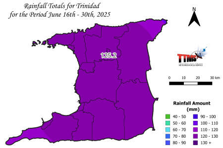
Figure 1. Rainfall map of Trinidad showing measured rainfall totals for varying districts during the period 16th to 30th of June.
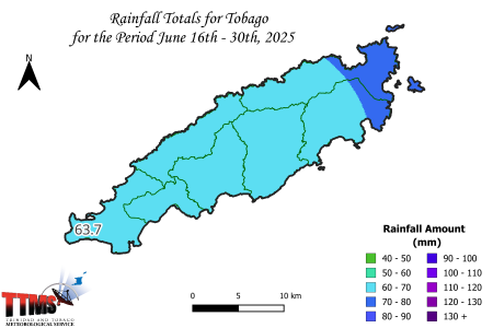
Figure 2. Rainfall map of Tobago showing measured rainfall totals for varying districts during the period 16th to 30th of June.
Temperatures:
Warmer than normal nights continued through June, accelerating crop development but also maintaining the moderate risk of pests and disease, especially in wind-sheltered areas. Daytime temperatures remained near normal. Piarco observed no hot days (maximum temperature over 34.0 ⁰C) with a maximum daytime temperature 32.9 ⁰C (27th) however, the night-time minimum temperatures ranged from 23.8 ⁰C to 26.1 ⁰C at Piarco. Tobago also experienced warm nights and no hot days (maximum temperatures above 33.0 ⁰C at Crown Point). The maximum daytime temperature was 31.3 ⁰C (27th) and the minimum temperatures ranged from 24.2 ⁰C to 26.6 ⁰C at Crown Point. Factoring the relative humidity however these temperatures had a ‘real feel’ that was higher than the observed maximum temperature.
Agro-meteorological Forecast:
Date | Weather | Temperature | Heat Index ‘Feels Like’ | Day Moisture (Relative Humidity) | Wind | ||
1 |  30% chance of rainfall | 1-3 mm of rainfall is possible | Hazy, breezy, partly cloudy, few showers |  Warm Max/Min Temperatures 32°C/25°C | Feels like 34°C-35°C | 52-75% |  East-northeast 20-39 km/h Gust 50 km/h |
2 | 30% chance of rainfall | 1-6 mm of rainfall is possible | Hazy, breezy, partly cloudy, few showers | Warm Max/Min Temperatures 32°C/25°C | Feels like 35°C-37°C | 60-75% | East-northeast 20-39 km/h Gust 50 km/h |
3 | 30% chance of rainfall | 1-6 mm of rainfall is possible | Partly to mostly cloudy,breezy, isolated thunderstorm | Warm Max/Min Temperatures 31°C/25°C | Feels like 35°C-35°C | 61-75% | East-northeast 20-39 km/h Gust 50 km/h |
4 |  70% chance of rainfall | 3-15 mm of rainfall is possible | Partly to mostly cloudy, breezy, isolated heavy shower/thunderstorm | Warm Max/Min Temperatures 31°C/24°C | Feels like 34°C-34°C | 57-80% | East-southeast 20-39 km/h Gust 50 km/h |
5 |  70% chance of rainfall | 3-12 mm of rainfall is possible | Partly to mostly cloudy, isolated heavy shower/thunderstorm | Warm Max/Min Temperatures 31°C/24°C | Feels like 35°C-35°C | 62-81% | East-southeast 20-30 km/h Gust 50 km/h |
6 |  70% chance of rainfall | 2-8 mm of rainfall is possible | Partly to mostly cloudy, isolated heavy shower/thunderstorm |  Very Warm Max/Min Temperatures 33°C/24°C | Feels like 33°C-36°C | 50-72% | East-northeast 20-30 km/h Gust 50 km/h |
7 | 70% chance of rainfall | 2-8 mm of rainfall is possible | Partly to mostly cloudy, isolated heavy shower/thunderstorm | Very Warm Max/Min Temperatures 33°C/24°C | Feels like 33°C-35°C | 46-75% | East-northeast 20-39 km/h Gust 50 km/h |
8 | 80% chance of rainfall | 3-10 mm of rainfall is possible | Mostly cloudy, isolated heavy shower/thunderstorm | Warm Max/Min Temperatures 31°C/24°C | Feels like 35°C-39°C | 73-75% | East 20-39 km/h Gust 50 km/h |
9 | 80% chance of rainfall | 3-10 mm of rainfall is possible | Mostly cloudy, isolated heavy shower/thunderstorm | Warm Max/Min Temperatures 31°C/24°C | Feels like 34°C-34°C | 55-74% | East-southeast 20-39 km/h Gust 50 km/h |
10 | 70% chance of rainfall | 3-10 mm of rainfall is possible | Partly to mostly cloudy, breezy, isolated heavy shower/thunderstorm | Warm Max/Min Temperatures 32°C/24°C | Feels like 37°C-39°C | 65-82% | East-southeast 20-39 km/h Gust 50 km/h |
11 | 70% chance of rainfall | 3-10 mm of rainfall is possible | Partly to mostly cloudy, breezy, isolated heavy shower/thunderstorm | Warm Max/Min Temperatures 32°C/24°C | Feels like 37°C-37°C | 60-75% | East 20-39 km/h Gust 50 km/h |
12 | 40% chance of rainfall | 2-8 mm of rainfall is possible | Partly to mostly cloudy, breezy, isolated heavy shower/thunderstorm | Warm Max/Min Temperatures 32°C/24°C | Feels like 37°C-37°C | 60-75% | East 20-39 km/h Gust 50 km/h |
13 | 60% chance of rainfall | 3-10 mm of rainfall is possible | Partly to mostly cloudy, breezy, isolated heavy shower/thunderstorm | Warm Max/Min Temperatures 32°C/24°C | Feels like 37°C-40°C | 70-83% | East 20-39 km/h Gust 50 km/h |
14 | 60% chance of rainfall | 2-10 mm of rainfall is possible | Partly to mostly cloudy, breezy, isolated heavy shower/thunderstorm | Warm Max/Min Temperatures 32°C/24°C | Feels like 35°C-36°C | 55-80% | East 20-39 km/h Gust 50 km/h |
15 | 60% chance of rainfall | 2-8 mm of rainfall is possible | Partly to mostly cloudy, breezy, isolated heavy shower/thunderstorm | Warm Max/Min Temperatures 32°C/24°C | Feels like 35°C-36°C | 58-77% | East 20-39 km/h Gust 50 km/h |
Trinidad Rainfall Forecast for the 15-Day period of July (1st to 15th) 2025.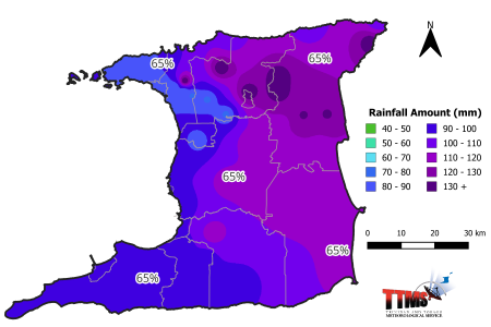
Figure 1. Rainfall map of Trinidad showing expected mean rainfall totals for districts across Trinidad during the 15-day period (1st to 15th) July 2025 and percentage probability of occurrence.
Eastern and North-Eastern areas: Moderate chance (65%) of mean daily rainfall up to 8.2 mm.
South-Eastern areas: High chance (75%) of mean daily rainfall up to 7.7 mm.
Southern areas: High chance (75%) of mean daily rainfall up to 6.6 mm.
South-Western areas: High chance (75%) of mean daily rainfall up to 6.4 mm.
Central, West-Central, and inland areas: Moderate chance (65%) of mean daily rainfall up to 6.7 mm.
Northern, North-Western areas: Moderate chance (65%) of mean daily rainfall up to 6.4 mm.
Tobago Rainfall Forecast for the 15-Day period of July (1st to 15th) 2025.
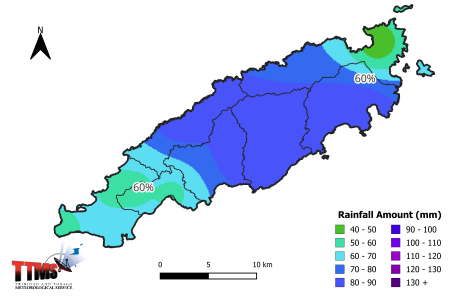
Figure 2. Rainfall map of Tobago showing expected mean rainfall totals for districts across Tobago during the 15-day period (1st to 15th) July 2025 and percentage probability of occurrence.
North-Eastern areas: Moderate chance (60%) of mean daily rainfall up to 5.2 mm.
South-Western areas: Moderate chance (60%) of mean daily rainfall up to 4.3 mm.
Trinidad and Tobago:
For the 15-days, partly to mostly cloudy conditions will be interrupted by showers (80% chance) with a moderate chance (60%) of heavy showers and thunderstorms with gusty winds favoring areas of eastern Trinidad and the majority of Tobago. Near to below normal rainfall is expected during the first week 1st- 7th then near normal in the second week 8th - 15th. The 15-day period forecast rainfall totals in Trinidad are expected to range between 77 mm over northwestern areas to 141 mm over southeastern and central Trinidad. In Tobago, 15-day forecast rainfall is expected to range between 45 mm and 88 mm favoring farmlands on southeastern lowland areas and eastern hillsides. The passage of several tropical waves will encourage equatorial moisture of the ITCZ over Trinidad and Tobago, so there is a moderate to high (70%) chance of moderately wet to very wet conditions to persist across most farmlands during the period.
Temperatures & Winds:
There’s a moderate (55%) chance of warmer than average temperatures particularly at night during the 15-days. Combined with near normal daytime temperatures and above normal nighttime temperatures, there’s a low (20%) chance of a 2-day hot spell overall. Forecast daily maximum temperatures will range from 29-32 °C in Tobago and 30-33 °C in Trinidad. Temperatures are expected to feel as hot as 33-40°C when factoring humidity on the warmest days. Minimum temperatures of 24-27°C are expected during most nights/early mornings, though warmer near western areas and coastlines.
A breezier first week (1st - 7th) is expected with moderate to fresh easterly winds. Occasional breezy spells with gusts of 50 km/h or higher possible near heavy showers or isolated thunderstorms. Evapotranspiration rates in crops of 2.0 mm to 4.0 mm per day are expected, when combined with near-normal daytime temperatures.
Moisture levels:
Moderate to occasionally high moisture levels are expected across Trinidad and Tobago over the fifteen-day period, with average daytime relative humidity values expected from the high-40s to mid-80s, in terms of percentage.
Highlighted Possible Impacts on Agriculture:
During the 15-days, moderately wet conditions are expected to persist over farmlands in Trinidad especially across the plains of Caroni and Naparima. In Tobago, however, a slight drying is likely over western areas. Heavy showers occurring on saturated soils of central and southern areas of Trinidad will bring a moderate to high risk of overfilling ponds, flash flooding and land slippage on fields and access roads.
A low to moderate (30%) chance of heat stress exists for farm workers, young livestock, newly germinated and transplanted seedlings onto fields. There is a moderate (40%) chance that strong gusts will damage young plants and flowering mature plants in exposed hilly areas. There is a moderate (60%) chance for fungal spread, insect pests and warm/moist weather diseases to develop in crop beds.
Continue to monitor streams and nearby watercourse levels. Implement pest and disease control measures as recommended. Monitor crops and animals for signs of heat stress and irrigate crops as needed especially in the flowering stage.
Sun and Moon Positions in the Sky July (1st to 15th) 2025.
The sun is presently overhead at latitude 23 degrees North of the Equator. The day-length or number of sunlight hours in Trinidad and Tobago on July 1st will be 12 hours, 44 minutes, 10 seconds decreasing to 12 hours, 41 minutes, 7 seconds on July 15th.
Moon Phases: First Quarter, 2nd; Full Moon, 10th. According to the tradition of moon phases: July 1st - 5th and 9th are good days for planting above-ground crops; 10th, 13th – 15th are good days for planting below-ground crops; the remaining days are poor planting days and useful for removing weeds, clearing land and ploughing fields.