OFFICIAL STATEMENT #3
Potential Tropical Cyclone Five
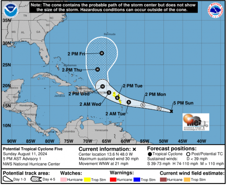
The Trinidad and Tobago Meteorological Service is monitoring an area of disturbed weather, Potential Tropical Cyclone Five (Figure 1) near 48W or approximately 1530 km east south-east of Antigua. At 5:00 pm today (Sunday 11th August 2024), the system is moving toward the west-northwest near 21 mph (33 km/h) and this motion is expected to continue during the next couple of days. On the forecast track, the disturbance is expected to move across portions of the Leeward Islands on Tuesday and approach the U.S. and British Virgin Islands Tuesday night.
Some strengthening is forecast, and the system is expected to become a Tropical Storm by late Monday. The system has a high (80%) chance of formation through the next 48 hours and a high (90%) chance of formation through the next 7 days.
A Tropical Storm Watch is in effect for Guadeloupe, St. Kitts, Nevis, Montserrat, Antigua, Barbuda, Anguilla, Saba, St. Eustatius, St. Martin and Sint Maarten.
On this current track, this system should not directly impact Trinidad and Tobago.
THERE ARE CURRENTLY NO WATCHES OR WARNINGS IN EFFECT FOR TRINIDAD AND TOBAGO. The TTMS continues to monitor this area of disturbed weather and will issue an update at 8:00am tomorrow, Monday 12th August, 2024 or earlier if the situation warrants.
As always, pay close attention to information being issued by the TTMS by visiting www.metoffice.gov.tt, downloading our mobile app (search: TT Met Office) and following us on X, Facebook and Instagram.

Fig. 1: Five day outlook for Potential Tropical Cyclone Five
Carrie Chapman Dumas
Meteorologist,
Trinidad and Tobago Meteorological Service