Rainfall and Temperature Outlook for Trinidad and Tobago, April to June 2024
ISSUED AT: 02:46 PM
Date: Monday 25th of March 2024


Key Messages
- Moderate chances exist for mostly near-normal rainfall totals during April to June (AMJ) over Trinidad and Tobago;
- Near-normal means that a range of 75% to 125% of the average rainfall amounts are possible;
- Some small pockets may experience above-normal rainfall;
- Enhanced chances for an above-average number of extremely wet days (> 25.0 mm);
- May has a higher chance for above-normal rainfall;
- AMJ period rainfall totals with the highest chance of occurring range between 277.0-728.0 mm in Trinidad and between 234.0-482.0 mm in Tobago;
- Both day and night temperatures are predicted to be above average for most of Trinidad and Tobago with high (70%) probabilities for short-duration hot spells from April to June;
Likely Impacts
- Mostly near average rainfall totals are expected during April to June with high chances for above-normal number of wet days and high chances for flooding to occur in May and June.
- An increase in surface water ponding in areas can promote mosquito breeding. This will increase the risk for higher incidences of vector-borne diseases.
- Frequent rainfall events, mixed with warm and humid conditions tend to promote rapid multiplication of some agricultural pests, diseases and fungal growth.
- High probability exists for high fly and mosquito populations.
Rainfall and Temperature Outlook for Trinidad and Tobago, April to June 2024
ISSUED AT: 02:46 PM
Date: Monday 25th of March 2024
Mostly Near-Normal Rainfall for the April to June Period: Flooding Potential is Moderate
Key Messages:
- Moderate chances exist for mostly near-normal rainfall totals during April to June (AMJ) over Trinidad and Tobago;
- Near-normal means that a range of 75% to 125% of the average rainfall amounts are possible;
- Some small pockets may experience above-normal rainfall;
- Enhanced chances for an above average number of extremely wet days (> 25.0 mm);
- May has a higher chance for above-normal rainfall;
- AMJ period rainfall totals with the highest chance of occurring range between 277.0-728.0 mm in Trinidad and between 234.0-482.0 mm in Tobago;
- Both day and night temperatures are predicted to be above average for most of Trinidad and Tobago with high (70%) probabilities for short-duration hot spells from April to June;
Likely Impacts :
- Mostly near average rainfall totals are expected during April to June with high chances for above-normal number of wet days and high chances for flooding to occur in May and June.
- An increase in surface water ponding in areas can promote mosquito breeding. This will increase the risk for higher incidences of vector-borne diseases.
- Frequent rainfall events, mixed with warm and humid conditions tend to promote rapid multiplication of some agricultural pests, diseases and fungal growth.
- High probability exists for high fly and mosquito populations.
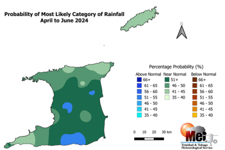
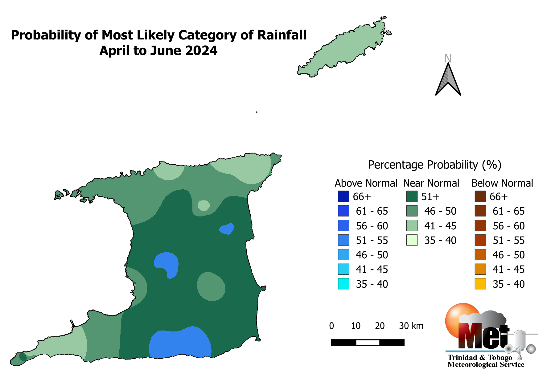
Figure 1: Category of rainfall likely for AMJ (April to June) 2024 with the highest chance of occurrence expressed as probabilities represented on the map. Blue areas indicate places with an increased chance for above normal rainfall, brown areas show an increased chance for below normal rainfall, while green areas show an increased chance for near normal rainfall. Normal is defined by the rainfall that was observed in middle one-third of the AMJ period rainfall totals during the historical period used to produce the outlook.
- Moderate probability exists for mostly near-normal rainfall totals over most parts of Trinidad and Tobago during AMJ;
- Chances are high (75%) for the above-normal number of extremely wet days (> 25.0 mm) for AMJ; i.e. expect between (3– 7) extremely wet days in Trinidad and (3-8) in Tobago during the period.
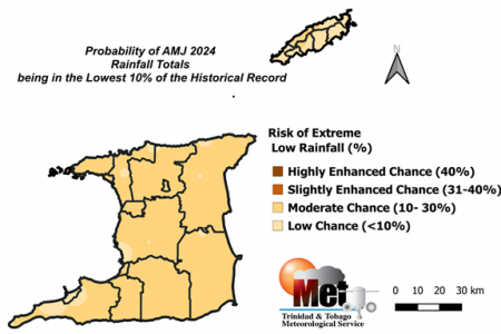
Figure 2: Risk of the AMJ 2024 being extremely drier than normal (within the lowest 10% on record).
- The risk of extremely drier than normal conditions is low to moderate (6-20%) over Trinidad;
- The risk of extremely drier than normal conditions is low to moderate (6-21%) over Tobago;
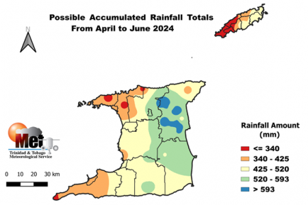
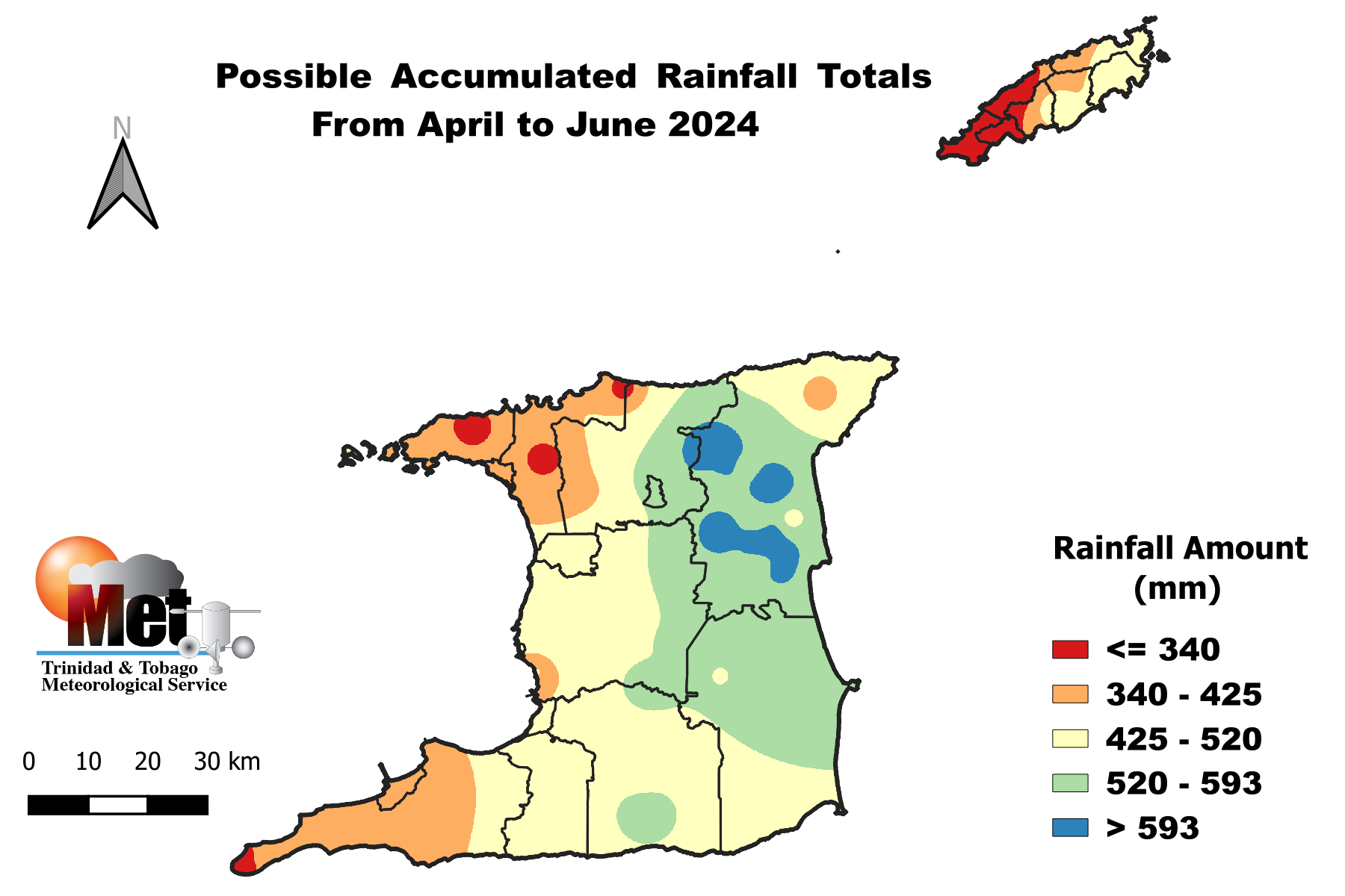
Figure 3: Outlook of possible rainfall accumulated totals for April to June, with the highest chance of occurring.
- Largest rainfall accumulated totals for AMJ are likely to be as high as 728.0 mm in areas such as North Oropouche, Valencia, Sangre Grande and Plum Mitan in Northeast and east Trinidad; and near 482.0 mm in Goodwood, Charlottesville and environs in northeast Tobago.

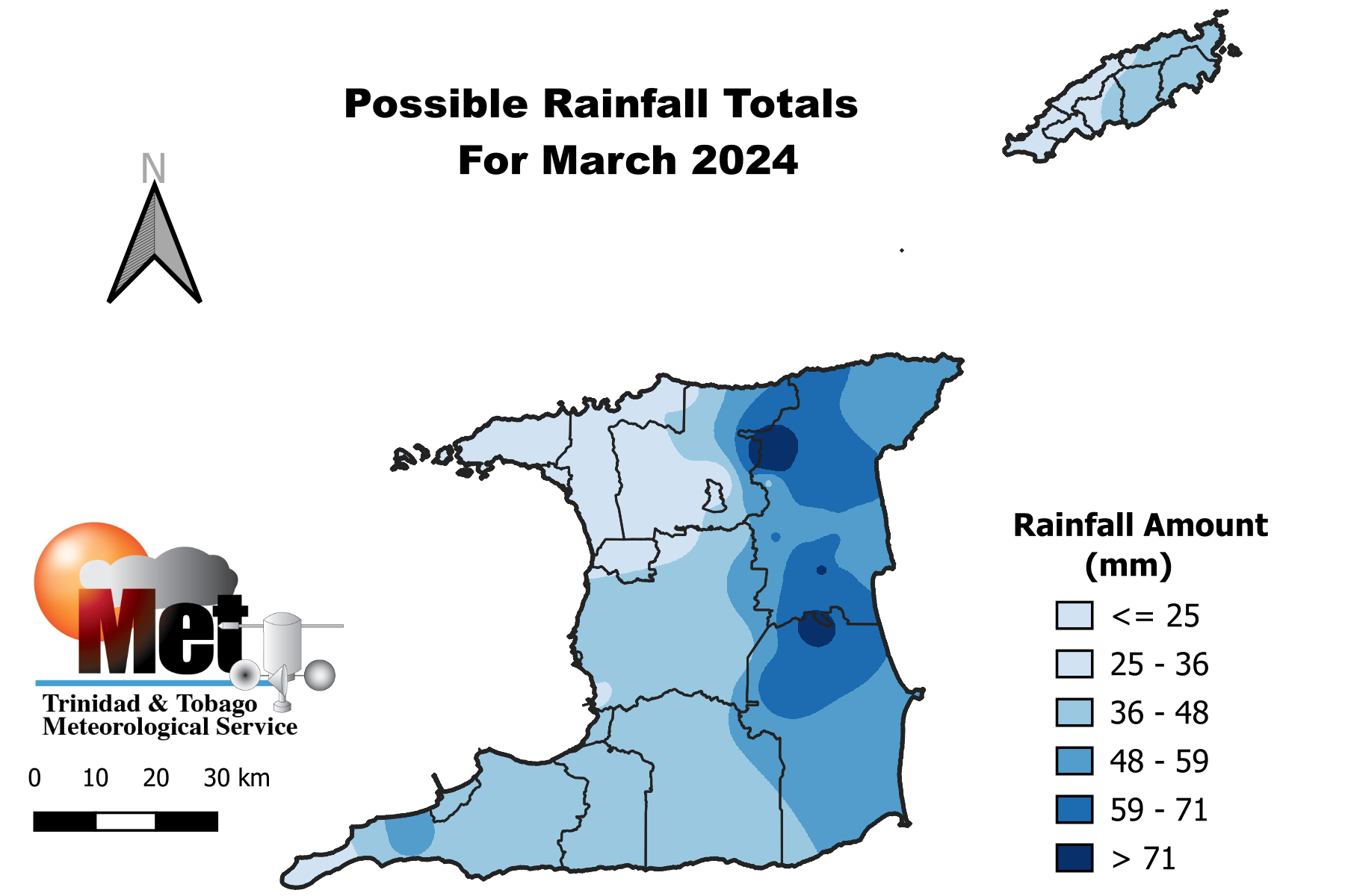
Figure 4: Possible rainfall totals for March 2024.
- March rainfall with highest chance of occurring ranges from about 16.0-86.0 mm in Trinidad and 13.5-47.0 mm in Tobago.
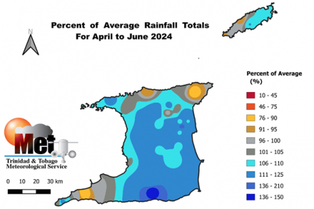
Figure 5: Percentage of Average Rainfall Totals for April to June 2024.
- April to June (AMJ) rainfall totals are likely to be mostly-near normal over most of Trinidad and Tobago;
- Few small wetter than usual pockets are likely to occur over central and southern Trinidad;

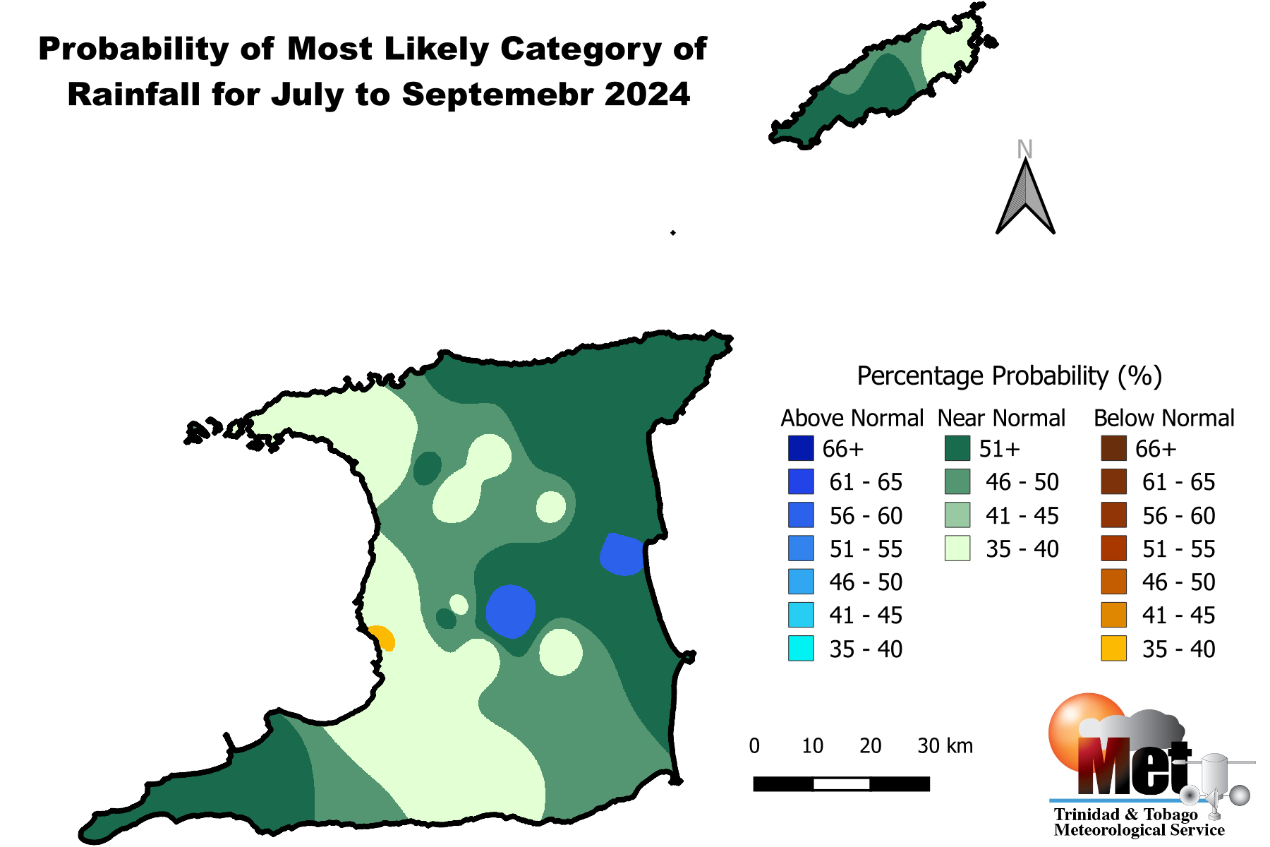
Figure 6: Category of rainfall likely for July to September (JAS) 2024 with the highest chance of occurrence expressed as probabilities represented on the map. Blue areas indicate places with an increased chance for above normal rainfall, brown areas show an increased chance for below normal rainfall, while green areas show an increased chance for near normal rainfall. Normal is defined by the rainfall that was observed in middle one-third of the JAS seasons during the historical period used to produce the outlook.
- High probability of mostly near-normal rainfall totals are expected during the period July to September 2024 over Trinidad and Tobago;
- Possible small pockets of above-normal rainfall totals are likely in central and east Trinidad while small pockets of below-normal rainfall can occur in southern parts of Trinidad.
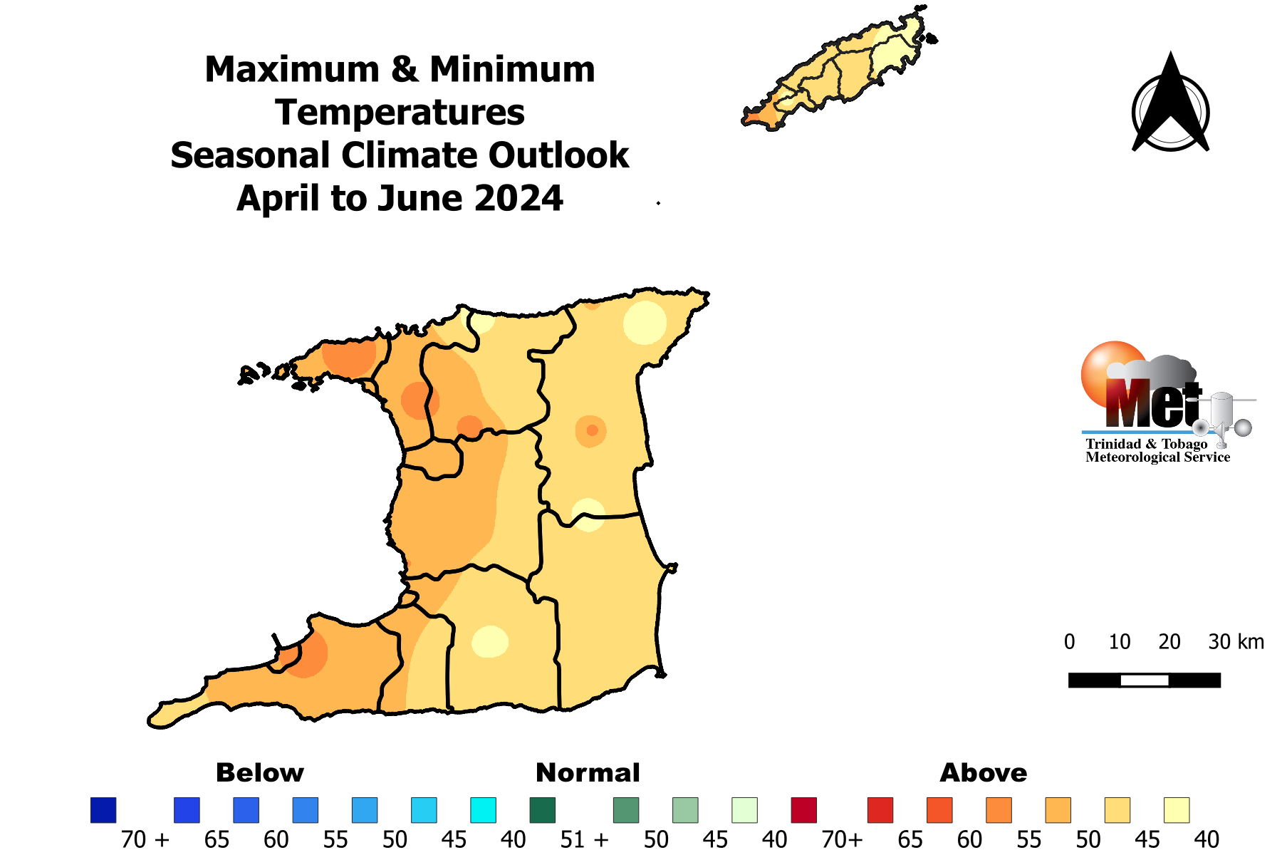
The Temperature Outlook Favours Above Normal Temperatures for April to June 2024.
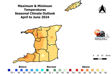
- Both daytime and night temperatures are likely to be warmer than average over both islands;
- There is a high (80%) chance of warmer than average days in urban and built up areas in Trinidad and Tobago;
- Chances of warmer than average nights are highest in Trinidad where there is 65% chance, while Tobago has a 60% chance;
- A high chance (75%) exist for short duration hot spells during AMJ with maximum temperatures 34.0oC or greater in Trinidad, 33.0oC or greater in Tobago;
How Should You Respond? Take Early Action!
Health Sector:
- Clear bushes, open drainage systems, fumigate in and around residences;
- Revisit contingency plans to manage spike in vector borne incidences and rainfall related infections.
Disaster Risk Management Sector:
- Sensitize communities on the forecast and its negative impacts;
- Revisit early warning information dissemination channels;
- Alert communities in low lying areas (flood prone) to act early;
- Alert at risk residence and communities that are still prone to landslide and slip.
Agriculture & Food Security Sector
- Practice soil moisture conservation like mulching and trenches;
- Clear vegetation from crop beds and drains to ease waterlogged soils.
- Put in place disease control measures.
Water, Drainage and Energy sector
- Implement water harvesting, storage and proper usage;
- Conduct routine de-silting of water channels, canals and reservoirs;
- Remove dry branches, trees and overhang near electrical wires.
General Public
- Proper preparation especially for persons in at risk areas;
- Clean drains and surrounding areas of debris, be sand-bag ready;
- Conserve, store and manage water in a safe and adequate manner;
- Be watchful for extreme rainfall events especially on extremely hot days;
- Take measures to lessen the potential impacts from the expected increased rainfall and warmer than average temperatures.
Be vigilant and visit the Met Service website regularly to keep up to date on local weather changes daily at www.metoffice.gov.tt or download our mobile app on Google Play Store or Apple iStore.
Climatic Influencers and Context of the Outlook
- Currently, sea surface temperatures (SSTs) in waters surrounding Trinidad and Tobago and further east of the islands are above average. Most climate models surveyed favour above average conditions to persist throughout the period April to June 2024.
- El Niño conditions will continue to weaken during April to June (AMJ) 2024 to ENSO-neutral conditions. Afterwards a changeover to La Niña conditions are expected in July to September (JAS). Weak El Niño to ENSO-neutral conditions generally have some influence on local cloudiness and rainfall, but not always. There is high probability that localized climate features will dominate the AMJ season;
- The North Atlantic Oscillation (NAO) was observed in a weak positive phase throughout February and forecast to continue in April. The overall influence should be a small positive impact on local rainfall.
- The Madden Julian Oscillation (MJO) signal will be over Trinidad and Tobago in April. This will have positive influence on April’s rainfall.