Agro-Meteorological Bulletin for the Second 15-Day Period (16th - 30th) of April, 2026
ISSUED AT: 11:23 AM
Date: Thursday 16th of April 2026
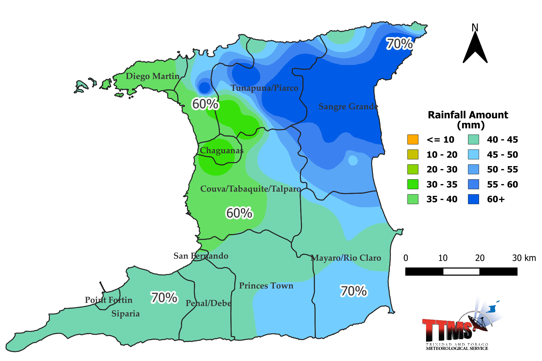
Figure 1.

Figure 2.
Summary:
Summary of Expected conditions:
From 16th to 30th April 2026, near- to above-normal rainfall with wet days (23rd , 24th, 25th and 26th) are expected to maintain soil moisture and reduce vegetation browning across farmlands. Although very warm at times, there is a low risk of heat-related hazards.
Agro-Meteorological Bulletin for the Second 15-Day Period (16th - 30th) of April, 2026
ISSUED AT: 11:23 AM
Date: Thursday 16th of April 2026
Definitions used in the forecast and bulletin:
| Term | Meaning | |
|---|---|---|
| Dekad | 10 day rainfall measuring period | |
| Rain Day | A day with 1.0 mm or more of rainfall amount | |
| Wet Day | A day with 10.0 mm or more rainfall amount | |
| Extremely Wet Day | A day with 25.0 mm or more of rainfall amount | |
| Normal Rainfall | Between 75% and 125% of the average | |
| Below Normal Rainfall | Rainfall below 75% of the average | |
| Above Normal Rainfall | Rainfall in excess of 125% of the average | |
| Much Below Normal Rainfall | Rainfall below 50% of the average | |
| Much Above Normal Rainfall | Rainfall above 150% of the average | |
| Scanty Rainfall | Less than 1 mm | |
| Moderate Rainfall | 1-10 mm | |
| Heavy Rainfall | 10-50 mm | |
| Very Heavy Rainfall | Greater than 50 mm | |
| Probability of 1-30 % | Low Chance | |
| Probability of 30-70 % | Moderate Chance | |
| Probability greater than 70 % | High Chance | |
| Term | Amount of Rain | Type of day |
| Scanty Rainfall | Less than 1 mm | Relatively dry day |
| Moderate Rainfall | 1-10 mm | Relatively wet day |
| Heavy Rainfall | 10-50 mm | Wet day |
| Very Heavy Rainfall | Greater than 50 mm | Excessively wet day |
Summary of Expected conditions:
From 16th to 30th April 2026, near- to above-normal rainfall with wet days (23rd , 24th, 25th and 26th) are expected to maintain soil moisture and reduce vegetation browning across farmlands. Although very warm at times, there is a low risk of heat-related hazards.
Weather Assessment for the period 1st to 15th April 2026.
Across north-central Trinidad and Piarco, moistened soil and less vegetation browning was noticed across various farmlands. Borderline dry conditions at the end of March eased temporarily by the 15th April. Although the drying trend has continued across Tobago early April, there is no concern of agricultural drought so far, TTMS Dryness/Drought Monitor and Outlook.
Rainfall:
During the 15 days, Trinidad has experienced much above normal rainfall. At Piarco, 61.4 mm was recorded from two wet days (with ≥ 10 mm) and two relatively wet days (with ≥ 1 mm). The highest daily total recorded was 40.2 mm (4th ) followed by 13.2 mm (5th). Tobago meanwhile has experienced much below normal up to the 15th April. Crown Point received 10.7 mm from five relatively wet days (with ≥ 1 mm) . The rainfall totals maps for the period 1st to 15th April for Trinidad and Tobago are located below as figure 1 and figure 2.
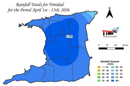
Figure 1. Rainfall map of Trinidad showing measured rainfall totals for varying districts during the period 1st to 15th of April 2026.
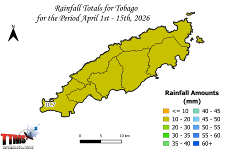
Figure 2. Rainfall map of Tobago showing measured rainfall totals for varying districts during the period 1st to 15th of April 2026.
Temperatures:
For the first half of April 2026, no hot days/spells were observed at either Piarco (maximum temperature at least 34.0 ⁰C) or Crown Point (maximum temperature at least 33.0 ⁰C). Mainly near normal daytime temperatures have prevailed at Piarco with the highest maximum daytime temperature 32.9 ⁰C (2nd) with a ‘real feel’ of 36 ⁰C. Crown Point has also observed near normal daytime temperatures with a maximum daytime temperature 31.4 ⁰C (15th). Factoring the relative humidity however these temperatures have a ‘real feel’ that is higher than the observed maximum temperature.
From 1st to 15th of April, nighttime temperatures were mainly above-normal. The 11th was the warmest night over the 15 days, 24.9 ⁰C at Piarco and 26.3 °C at Crown Point.
Agro-meteorological Forecast:
Date | Weather | Temperature | Heat ‘Real Feel’ | Day Moisture (Relative Humidity) | Wind | ||
|---|---|---|---|---|---|---|---|
16 |
| 1-6 mm of rainfall is possible | Partly cloudy, hazy, breezy, isolated showers |
Warm Max/Min Temperatures 32°C/24°C | Feels like 35°C-36°C | 55-75% |
East 20-30 km/h Gust 50 km/h |
17 |  70% chance of rainfall | 1-8 mm of rainfall is possible | Partly to mostly cloudy, hazy, isolated showers |  Warm Max/Min Temperatures 32°C/24°C | Feels like 35°C-37°C | 59-75% |  East 20-30 km/h Gust 50 km/h |
18 |  70% chance of rainfall | 1-8 mm of rainfall is possible | Partly to mostly cloudy, isolated thunderstorm | Warm Max/Min Temperatures 32°C/23°C | Feels like 34°C-35°C | 51-75% |  East 20-30 km/h Gust 50 km/h |
19 |  40% chance of rainfall | 1-5 mm of rainfall is possible | Partly to mostly cloudy, isolated showers |  Very Warm Max/Min Temperatures 33°C/23°C | Feels like 34°C-35°C | 46-70% |  East-northeast 20-30 km/h Gust 50 km/h |
20 |  40% chance of rainfall | 1-6 mm of rainfall is possible | Partly to mostly cloudy, isolated showers |  Very Warm Max/Min Temperatures 33°C/23°C | Feels like 34°C-37°C | 53-70% |  East-northeast 11-30 km/h Gust 50 km/h |
21 |  40% chance of rainfall | 2-6 mm of rainfall is possible | Partly to mostly cloudy, hazy, isolated showers |  Very Warm Max/Min Temperatures 33°C/23°C | Feels like 34°C-38°C | 55-70% |  East-northeast 11-30 km/h Gust 50 km/h |
22 |  60% chance of rainfall | 2-8 mm of rainfall is possible | Mostly cloudy,hazy, scattered showers |  Warm Max/Min Temperatures 32°C/23°C | Feels like 34°C-37°C | 51-70% |  East-southeast 11-30 km/h Gust 50 km/h |
23 |  70% chance of rainfall | 2-10 mm of rainfall is possible | Mostly cloudy, isolated heavy shower, thunderstorm |  Warm Max/Min Temperatures 32°C/23°C | Feels like 35°C-37°C | 60-80% |  East-southeast 11-30 km/h Gust 50 km/h |
24 |  70% chance of rainfall | 3-10 mm of rainfall is possible | Mostly cloudy, isolated heavy shower, thunderstorm |  Warm Max/Min Temperatures 32°C/23°C | Feels like 35°C-37°C | 60-80% |  East-southeast 11-30 km/h Gust 50 km/h |
25 |  70% chance of rainfall | 3-12 mm of rainfall is possible | Mostly cloudy, isolated heavy shower, thunderstorm |  Warm Max/Min Temperatures 32°C/24°C | Feels like 35°C-36°C | 55-80% |  East-southeast 11-30 km/h Gust 50 km/h |
26 |  70% chance of rainfall | 3-10 mm of rainfall is possible | Partly to mostly cloudy, isolated heavy shower, thunderstorm |  Warm Max/Min Temperatures 32°C/24°C | Feels like 34°C-36°C | 55-80% |  East-southeast 11-30 km/h Gust 50 km/h |
27 |  60% chance of rainfall | 2-8 mm of rainfall is possible | Partly to mostly cloudy, scattered showers |  Warm Max/Min Temperatures 32°C/24°C | Feels like 34°C-36°C | 50-75% |  East 11-30 km/h Gust 50 km/h |
28 |  60% chance of rainfall | 1-5 mm of rainfall is possible | Partly to mostly cloudy, isolated showers |  Very Warm Max/Min Temperatures 33°C/23°C | Feels like 35°C-38°C | 55-75% |  East 11-30 km/h Gust 50 km/h |
29 |  60% chance of rainfall | 1-5 mm of rainfall is possible | Partly to mostly cloudy, isolated showers |  Very Warm Max/Min Temperatures 33°C/23°C | Feels like 35°C-38°C | 55-75% |  East 11-30 km/h Gust 50 km/h |
30 |  60% chance of rainfall | 1-5 mm of rainfall is possible | Partly to mostly cloudy, isolated showers |  Very Warm Max/Min Temperatures 33°C/23°C | Feels like 35°C-38°C | 55-75% |  East 11-30 km/h Gust 50 km/h |
 40% chance of rainfall

Trinidad Rainfall Forecast for the 15-Day period of April (16th to 30th) 2026.

Figure 3. Rainfall map of Trinidad showing expected mean rainfall totals for districts across Trinidad during the 15-day period (16th to 30th April 2026) and percentage probability of occurrence.
Eastern and North-Eastern areas: Moderate chance (70%) of mean daily rainfall up to 4.0 mm.
South-Eastern areas: Moderate chance (70%) of mean daily rainfall up to 3.0 mm.
Southern areas: Moderate chance (70%) of mean daily rainfall up to 2.9 mm.
South-Western areas: Moderate chance (70%) of mean daily rainfall up to 2.8 mm.
Central, West-Central, and inland areas: Moderate chance (60%) of mean daily rainfall up to 2.4 mm.
Northern, North-Western areas: Moderate chance (60%) of mean daily rainfall up to 2.9 mm.
Tobago Rainfall Forecast for the 15-Day period of April (16th to 30th) 2026.
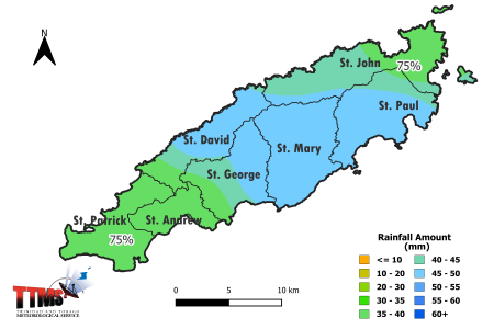
Figure 4. Rainfall map of Tobago showing expected mean rainfall totals for districts across Tobago during the 15-day period (16th to 30th April 2026) and percentage probability of occurrence.
North-Eastern areas: High chance (75%) of mean daily rainfall up to 3.0 mm.
South-Western areas: High chance (75%) of mean daily rainfall up to 2.6 mm.
Trinidad and Tobago:
There is a moderate (60-70%) chance of near- to above-normal rainfall 16th to 30th April 2026. The weather across most farmlands during this period will feature occasional light to moderate rainfall and mostly cloudy skies. Wet days with heavy showers and thunderstorms are mainly expected 23rd to 26th April.
The forecast rainfall totals (16-30th) across most farmlands will range between 31 mm and 79 mm in Trinidad, see figure 3, and between 36 mm and 47 mm in Tobago, see figure 4. However, isolated higher amounts up to 117mm are possible on upslope fields and along windward coasts.
There is a greater potential for cloudiness and precipitation/convection over the Guianas and Lesser Antilles despite bouts of dry Saharan dust/air during the period. Weaker than average surface winds present near the Guianas will cause upwelling of moist air across Trinidad and Tobago.
Temperatures & Winds:
There is a low risk of heat-related hazards across most of Trinidad and Tobago. Mainly warm conditions are expected nationwide with moderate (30-40%) chance of above normal daytime temperatures and a moderate (60%) chance of above normal nighttime temperatures. However western Trinidad has a moderate (30%) chance of three consecutive very warm days (33 °C) mainly towards the end of April.
Generally daily maximum temperatures of 30-32 °C are expected, but up to 33 °C in western Trinidad which could reach 34 °C in urban centres. When factoring humidity on the hottest days however, daytime conditions would feel as hot as 34°C to 38 °C in Trinidad. Generally nighttime minimum temperatures will range from 22 °C to 24 °C however cooler nights of 21°C are possible in elevated/sheltered valleys such as Paramin, Upper Maracas, Lopinot, Runnemede and Main Ridge.
Moderate winds generally from the east are expected, however, fresh to strong gusts are likely near hilltops and exposed eastern coastal areas. Average daily evaporation rates of 6.0 are expected but faster water loss is expected during very warm and breezy days during the period.
Moisture levels:
Daytime relative humidity levels are expected to range from the high-40s to high-70s in terms of percentage, with a peak of 80% on wet days, leading to occasional muggy conditions in western areas, particularly in the afternoons and evenings.
Highlighted Possible Impacts on Agriculture:
From 16th to 30th April 2026, near- to above-normal rainfall and wet days (23rd , 24th, 25th and 26th) are expected to maintain soil moisture and reduce vegetation browning across farmlands. Favorable weather conditions for agricultural activities are expected. Although very warm, there is a low risk of heat-related hazards for farm workers, young livestock, newly germinated/ transplanted seedlings onto fields.
Breezy conditions may possibly damage young plants and flowering mature plants on exposed hillsides. Moist conditions may develop however in wind-sheltered areas. When humidity is too high over crop beds, a higher risk of fungal, bacterial and viral infections exists.
During the odd heavy shower the risk of street/flash flooding increases, however, land slippage is not expected. Plumes of Saharan dust/air may significantly affect small ruminants and poultry.
Maintain wind-breaks and irrigate crops as needed especially in the flowering stage. Ensure regular weeding to reduce competition and water stress on crops. Implement pest and disease control measures as recommended.
Sun and Moon Positions in the Sky April (16th to 30th) 2026.
On the 16th April, the sun is directly overhead at latitude 10.3° degrees North of the Equator. The day-length or number of sunlight hours in Trinidad and Tobago on the 16th will be 12 hours, 22 minutes increasing to 12 hours, 30 minutes on the 30th April 2026.
Moon Phases: New Moon, 17th and First Quarter, 23rd. According to the tradition of moon phases: April 18th – 19th, 22nd – 23rd are good days for planting above -ground crops; April 28th - 30th are good days for planting below-ground crops. Remaining days are poor planting days and useful for removing weeds, clearing land and ploughing fields.