Rainfall and Temperature Outlook for Trinidad and Tobago, May to July 2026
ISSUED AT: 10:19 AM
Date: Thursday 30th of April 2026

Key Messages
- Moderate chances exist for near normal to below rainfall totals during May to July (MJJ) over Trinidad and Tobago;
- Near normal means that a range of 75% to 125% of the average rainfall amounts are possible;
- Below normal means that less than 75% of the average rainfall amounts are possible;
- In Trinidad, May has a moderate (52%) chance for near normal rainfall while June and July have higher probabilities of 64% and 62% respectfully;
- In Tobago, May to July has moderate (55%) chance for below normal rainfall;
- In Trinidad, moderate chances exist for above normal number of dry days (less than 1.0 mm) in May and near normal in June and July while Tobago has moderate probability for above normal number of dry days (less than 1.0 mm);
- MJJ period rainfall totals with highest chance of occurring range between 317-756 mm in Trinidad and between 264-469 mm in Tobago;
- There is a moderate (64%) chance of warmer than average days in urban and built up areas in Trinidad and Tobago;
- A moderate chance (62%) exist for short duration hot spells during May to July with maximum temperatures greater than 34.0oC in Trinidad and greater than 33.0oC in Tobago;
- The probability for MJJ rainfall totals to be in the lowest 10% of climatic normal is low to moderate (6%-25%) in Trinidad and moderate (11%-19%) in Tobago;
Likely Impacts
- Tobago not so much Trinidad, is expected to experience reduced water recharge rates and stream flows particularly in May. The expected reduced rainfall amounts in May will negatively impact surface water availability;
- Dry conditions usually lead to an increase in the need to collect and store water in tanks and containers. This can increase breeding areas for mosquitoes if not secured tightly;
- Dry conditions expected will increase the chances of bush, forest and landfill fires, especially in May. This will likely reduce air quality and negatively affect persons with existing respiratory and other ailments;
- In Trinidad, mostly average rainfall totals are expected during May to July with moderate chances for flooding to occur;
- In Tobago, mostly below average rainfall totals are expected during May to July with low to moderate chances for flooding to occur;
Rainfall and Temperature Outlook for Trinidad and Tobago, May to July 2026
ISSUED AT: 10:19 AM
Date: Thursday 30th of April 2026
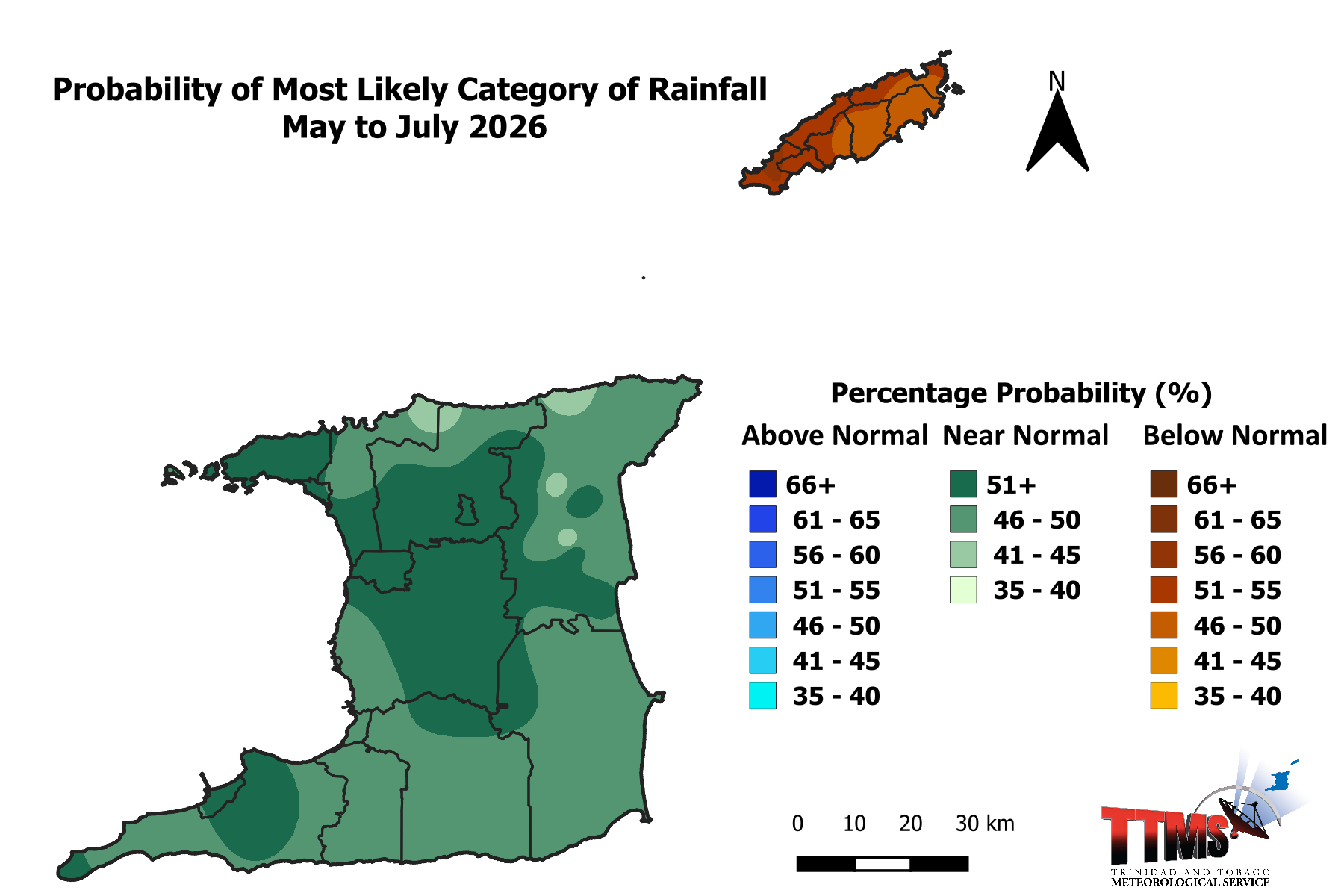
Near Normal to Below Normal Rainfall for May to July: Flooding Potential is moderate

Figure 1: Category of rainfall likely for MJJ (May to July) 2026 with the highest chance of occurrence expressed as probabilities represented on the map. Brown areas show an increased chance for below normal rainfall, while green areas show an increased chance for near normal rainfall. Normal is defined by the rainfall that was observed in middle one-third of the MJJ period rainfall totals during the historical period used to produce the outlook.
- Trinidad is expected to receive near normal rainfall while Tobago is expected to receive below normal rainfall amounts.
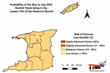
Figure 2: Risk of May to July (MJJ) 2026 being extremely drier than normal (within the lowest 10% on record).
- The risk of extremely drier than normal conditions is low to moderate (6-25%) over Trinidad;
- The risk of extremely drier than normal conditions is moderate (11-19%) over Tobago;

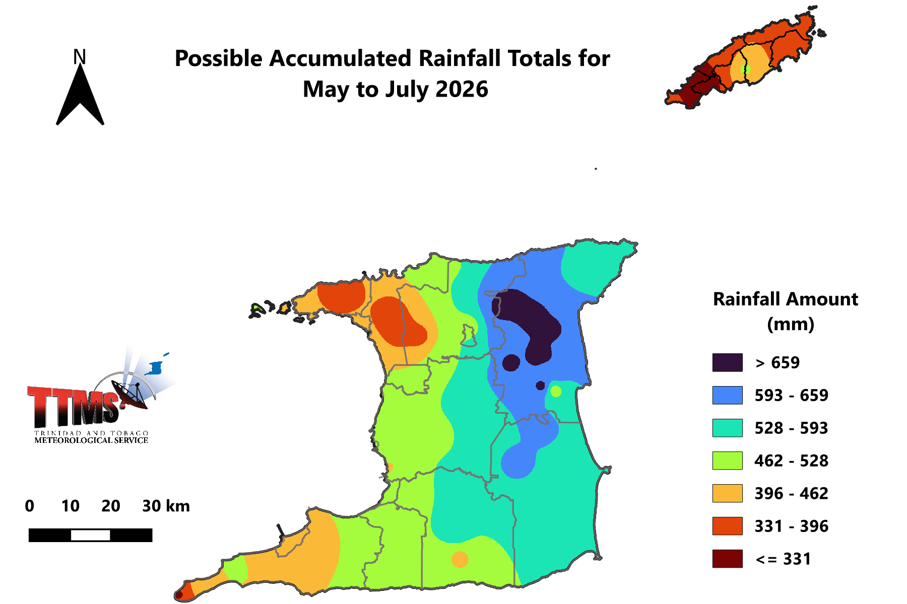
Figure 3: Outlook of possible rainfall accumulated totals for May to July, with the highest chance of occurring.
- Largest rainfall accumulated totals for May to July (MJJ) are likely to be as high as 756 mm in areas such as North Oropouche, Valencia and Sangre Grande in Northeast and east Trinidad; and near 469 mm in central Tobago in areas such as Goodwood and Fort Granby.

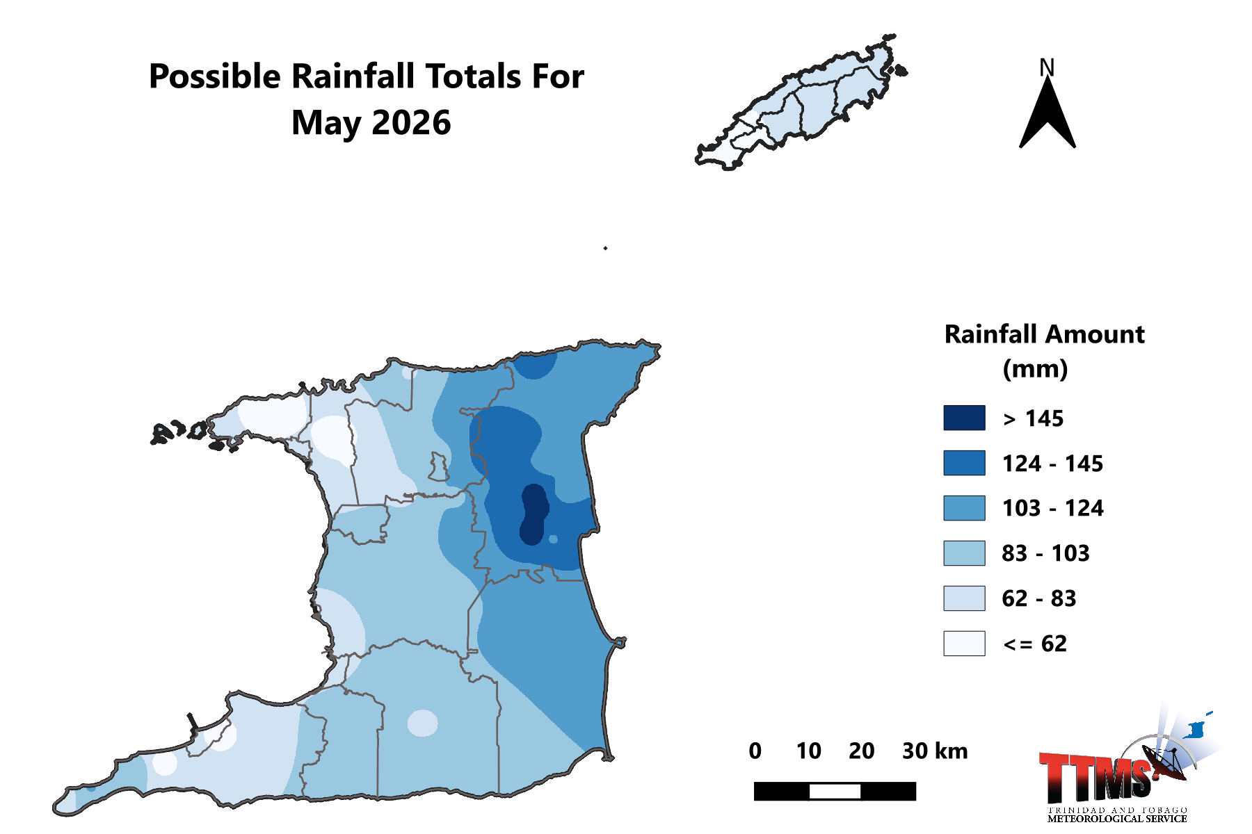
Figure 4: Possible rainfall totals for May 2026.
- May rainfall with highest chance of occurring ranges from about 40-169 mm in Trinidad and 50-81 mm in Tobago.

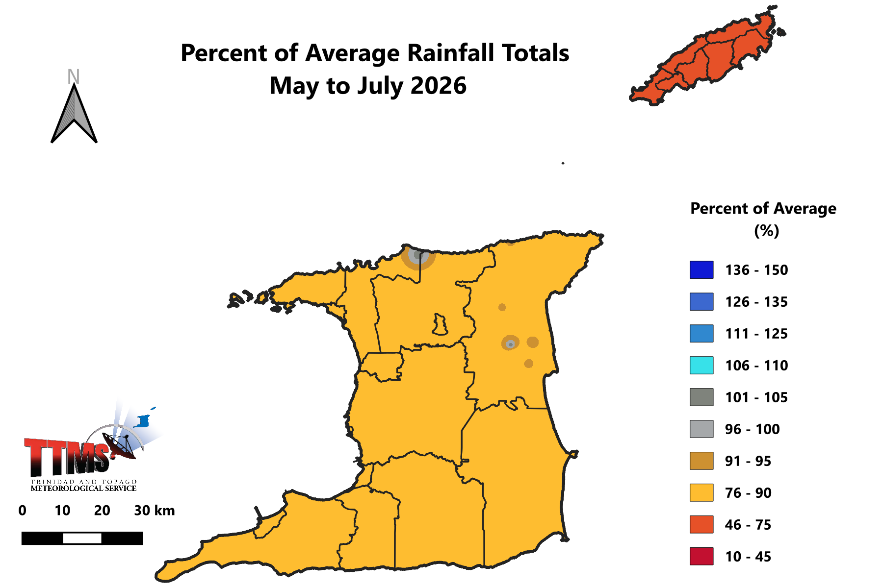
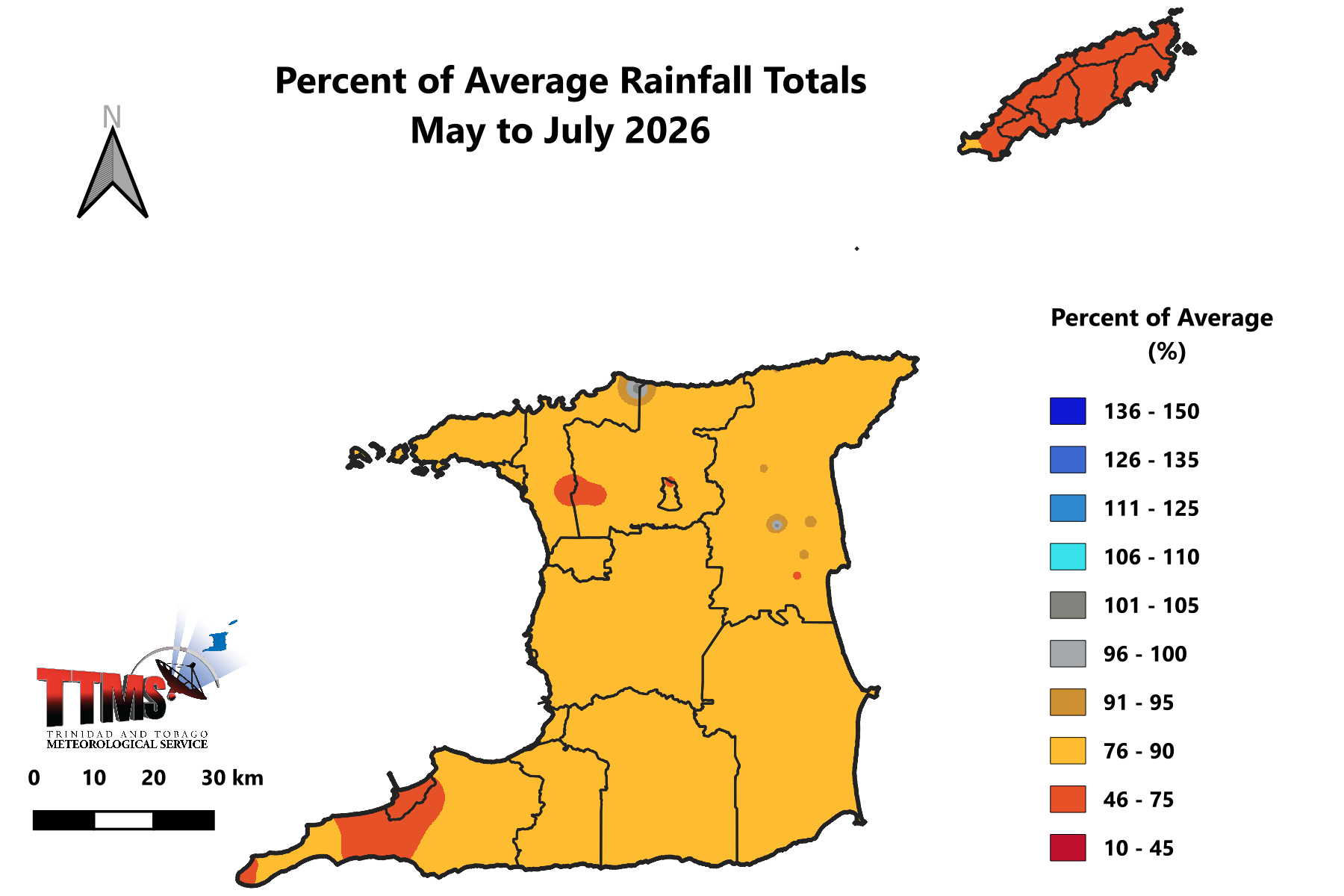
Figure 5: Percentage of Average Rainfall Totals for May to July 2026
- May to July (MJJ) rainfall totals are likely to be near normal over Trinidad but below normal over Tobago;
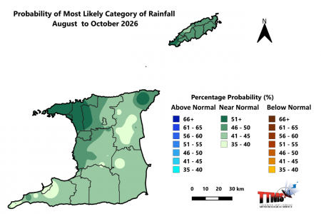
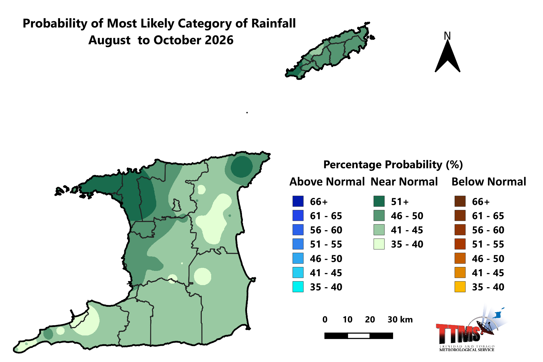
Figure 6: Category of rainfall likely for August to October (ASO) 2026 with the highest chance of occurrence expressed as probabilities represented on the map. Green areas show an increased chance for near normal rainfall. Normal is defined by the rainfall that was observed in middle one-third of the ASO seasons during the historical period used to produce the outlook.
- A moderate probability (30%-63%) exists for near normal rainfall totals during the period August to October 2026 over Trinidad and Tobago.

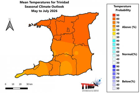
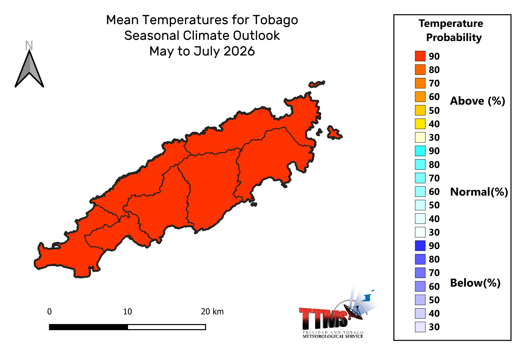
Figure 7: The map shows the colour-coded category (below-normal, above-normal, and near-normal) of mean temperatures that is most likely to occur across Trinidad and Tobago for the May to July (MJJ) period 2026. The colour-coded bar-graph with the numbers to the right gives the likelihood for each forecast category to occur.
The Temperature Outlook Favours Above Normal Temperatures for May to July 2026.
- There is a moderate (64%) chance of warmer than average days in urban and built up areas in Trinidad and Tobago;
- A moderate chance (62%) exists for short duration hot spells during May to July with maximum temperatures greater than 34.0oC in Trinidad and greater than 33.0oC in Tobago;
How Should You Respond? Take Early Action!
Health Sector:
- Clear bushes, open drainage systems, fumigate in and around residences;
- Revisit contingency plans to manage spike in vector borne incidences and rainfall related infections.
Disaster Risk Management Sector:
- Sensitize communities on the forecast and its negative impacts;
- Revisit early warning information dissemination channels;
Agriculture & Food Security Sector
- Practice soil moisture conservation like mulching and trenches;
- Clear vegetation from crop beds and drains to ease waterlogged soils.
- Put in place disease control measures.
Water, Drainage and Energy sector
- Implement water harvesting, storage and proper usage;
- Conduct routine de-silting of water channels, canals and reservoirs;
- Remove dry branches, trees and overhang near electrical wires and houses;
General Public
- Proper preparation especially for persons in at risk areas;
- Clean drains and surrounding areas of debris and dry vegetation;
- Conserve, store and manage water in a safe and adequate manner;
- Be vigilant of bush, forest and landfill fires;
Be vigilant and visit the Met Service website regularly to keep up to date on local weather changes daily at www.metoffice.gov.tt or download our mobile app on Google Play Store or Apple iStore.
Climatic Influencers and Context of the Outlook:
- Currently, sea surface temperatures (SSTs) in waters surrounding Trinidad and Tobago and further east of the islands are average to slightly above average. Most climate models surveyed favour average to slightly above average sea surface temperatures to persist throughout the period May to July 2026.
- Climate models have indicated with a moderate probability (61%) that El Niño conditions will develop during May to July and continue to the end of the year.
- The North Atlantic Oscillation (NAO) was observed in a strong positive phase throughout April and forecast to change to weak negative phase in May. The overall influence should be a small positive impact on local rainfall.
- Surface wind speeds are expected to be normal to above normal during May to July.
- The Madden Julian Oscillation (MJO) has stalled in the Indian Ocean and is not expected to influence rainfall amounts in the over Trinidad and Tobago during May 2026.
- The equatorial Rossby and Kelvin waves are not expected to influence rainfall amounts in May 2026.